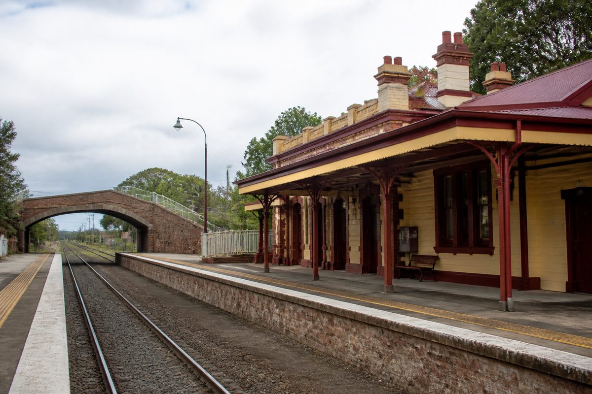
Bayswater grew from a thinly settled farming district into a railway town, postwar suburb and major job centre. Transport drove every stage. Rough roads and tracks opened the land. The railway gave the district a heart. Later, roads, factories and public works changed its size.
The suburb lies about 27 kilometres east of central Melbourne, between Ringwood, Victoria and Ferntree Gully. Its past also links with Scoresby, Victoria, as early settlers and public records often treated these places as one broad rural district.
The key dates tell a clear story. Bayswater grew as travel became easier, jobs moved closer and local government planned for more homes. Many small choices made over more than a century created the suburb seen today.
What was the Bayswater area like before a township formed?
For thousands of years, the land around Bayswater was part of the Country cared for by the Wurundjeri and Bunurong peoples of the Kulin Nation. Creeks, wetlands and foothills provided food and routes between the plains and the Dandenong Ranges.
European settlement changed the land during the nineteenth century. Surveyors split it into lots, while selectors cut down native bush for grazing, orchards and small farms. The work was slow. Heavy soil, thick timber and wet ground made sure of that. Early roads often turned to mud after rain.
The district didn't yet have the neat suburb borders shown on maps today. Residents described where they lived by nearby settlements, parishes or road names. Scoresby, Victoria was one common reference point. Ferntree Gully was another, since it had government services and links towards the ranges.
Most families lived far apart. Collecting supplies could take much of the day. Farmers needed steady routes to sell fruit, timber and other produce. That need shaped the first local roads and later made the railway a turning point.
How did Bayswater gain its name and local identity?
The name Bayswater appeared during the land sales and subdivisions of the late nineteenth century. It came from Bayswater in London, one of many British place names used across colonial Victoria.
Before the name stuck, parts of the area were called Scoresby North. That older name shows how slowly a local identity took shape. A handful of houses or farms didn't make a town. The district needed shared services and a known centre before residents could see it as a place of its own.
A school, postal services and meeting places helped form that identity. They gave scattered households a reason to gather. Local churches and community groups later made the bond between the Bayswater name and its residents even stronger.
The railway settled the issue. Once the station appeared on maps and timetables, Bayswater was easier to find and promote. Land agents could advertise blocks by their distance from the station. Traders could open shops near a steady stream of passengers.
Why did the railway change the district so much?
The railway reached Bayswater in 1889 as part of the line running east from Ringwood. The opening of Bayswater railway station, Melbourne gave the rural district a fixed centre and a quicker link to the city.
The early Bayswater railway carried more than commuters. Farmers could send produce with fewer delays. Building supplies arrived in bigger loads. Visitors also gained easier access to the foothills and nearby settlements.
A train station changed land values too. Blocks within walking or carting distance became more useful for homes and shops. Building began to cluster near the railway instead of spreading at random across the district.
The route now called the Ferntree Gully line tied Bayswater to Ringwood, Victoria and the wider suburban rail system. Ringwood became the main junction to the west, while services ran towards Ferntree Gully and later Belgrave. Bayswater now sat on a key path between Melbourne and the Dandenong Ranges.
Growth stayed modest for decades. Steam trains were slower and ran less often than modern services. Many roads remained poor. Still, the railway laid out the basic shape that later suburb growth would follow.
What did Bayswater look like in the early twentieth century?
Early twentieth-century Bayswater was still semi-rural. Orchards, poultry farms and grazing land surrounded a small cluster of shops and public buildings near the station. Families often grew food at home and bought basic goods from local traders.
Mountain Highway became the main east-west road through the settlement. It joined Bayswater to Wantirna and Ringwood in one direction and the foothills in the other. Scoresby Road ran north-south towards farming districts around Scoresby.
Better roads made carts and early motor vehicles more practical, but the railway remained the safest long-distance link. The station area was the local transport hub. Passengers, freight and shops all met in one small place.
Electric train services reached the district in the 1920s. Electrification made trips cleaner and more regular. In practical terms, it also pulled Bayswater closer to Melbourne. A journey that once took careful planning became manageable for workers and shoppers.
The change didn't turn Bayswater into a packed suburb overnight. The Great Depression and the Second World War slowed construction. Big blocks and open land were still common well into the postwar years.
When did Bayswater become a modern suburb?
The biggest shift came after 1945. Melbourne had a housing shortage, car ownership grew and families looked for affordable land beyond the old inner suburbs. Bayswater was ready for subdivision. It had open sites, rail and road access.
Population growth sped up during the 1950s and 1960s. Farms were cut into housing estates. Timber homes and brick veneer houses rose along new streets. Drainage, sealed roads and other services followed, although some residents waited years for all the work to reach their street.
Daily life changed. A family could live in Bayswater while one adult travelled elsewhere for work. Children went to growing local schools. Shopping strips spread around the old station centre.
The suburb also drew migrants who came to Australia after the war. Their work and small businesses helped build Melbourne's eastern suburbs. Bayswater became less rural and more closely linked to the wider city.
You can still see the pattern in its streets. Curved roads and courts often mark postwar estates, while older routes follow property lines or early transport paths. The age of the houses also shows how Bayswater spread out from the railway centre.
How did local government guide this expansion?
For many years, Bayswater was governed as part of the Shire of Ferntree Gully. Fast suburban growth put fresh strain on a council system built for a far more rural district.
In 1963, the western part of the shire broke away to form the Shire of Knox. Bayswater joined the new municipality. Knox became a city in 1969, creating the City of Knox known today.
The new local government had to serve fast-growing housing areas while setting aside land for business and industry. As the population rose, it handled roads, waste collection, libraries and recreation facilities. Planning rules also helped keep factory work apart from nearby homes.
This council change matters because it reflected a wider shift in Bayswater. The area was no longer a small settlement on Melbourne's fringe. It had joined a solid urban belt stretching across the eastern suburbs.
Why did industry become central to Bayswater?
Industrial growth took off from the 1960s. Wide areas south and west of the town centre had room for factories, warehouses and service firms. They also had handy access to Mountain Highway, Scoresby Road and the rail corridor.
The Bayswater industrial area became one of the suburb's main features. Manufacturers could secure bigger sites than those closer to central Melbourne. Freight trucks could reach the growing road network without travelling through the city centre.
These businesses turned Bayswater from a dormitory suburb into a place where many people worked as well as lived. Jobs opened in manufacturing, vehicle services, storage and wholesale trade. Smaller firms then grew around the larger businesses.
It created an unusual mix. Homes stood near a major job district, with the station and shopping centre tucked between transport routes. This mix helps explain why roads and public transport became constant planning concerns.
Industry changed the suburb's daily rhythm too. Morning traffic didn't flow in just one direction. Workers came in from nearby suburbs as residents headed out to jobs elsewhere. Bayswater was both a starting point and a destination.
How did roads reshape movement through Bayswater?
Car use climbed as postwar housing and industry grew. Mountain Highway carried more local traffic and became a key route across the eastern suburbs. Scoresby Road joined industrial sites and housing areas with suburbs to the south.
Road upgrades made travel easier but added pressure near the railway. Cars, buses, bikes and people on foot all had to cross or approach the same corridor. The old level crossing near the station became a choke point as road traffic and train services grew.
This clash was woven into Bayswater's history. The railway had formed the town centre, but the later road network demanded far more from that same narrow space than early planners could have guessed.
Shops also spread beyond the old station strip. Bigger shopping centres elsewhere in Knox drew customers by car. Bayswater's centre still met local needs, but it had to compete with places built around broad roads and vast car parks.
What changed when the level crossing was removed?
A major rebuilding project removed the Mountain Highway level crossing in 2016. The rail line was lowered beneath the road, and a new station took the place of the old facilities.
The project ended the direct clash between trains and road traffic. It also changed how people travelled through the centre. New paths and station entrances improved links across the rail corridor. The rebuilt bus interchange made the area a stronger transport hub.
The work opened a new chapter in the history of Bayswater railway station, Melbourne. The station was no longer a small stop left over from an outer rural line. It became part of a busy metropolitan system used by residents and workers.
The project also showed the lasting impact of the 1889 choice to run the railway through Bayswater. More than a century later, public spending still focused on the same transport spine.
Which parts of old Bayswater can still be seen?
Most of the rural scenery has gone, but clues from each period remain. The rail line marks the first strong centre. Mountain Highway follows the route that joined early settlements. Scoresby Road keeps the old link with land to the south.
Older houses near the centre show the scale of Bayswater before the big postwar estates arrived. Community buildings and street names may point to early families, former farms or landmarks that have vanished.
The industrial precinct records the next wave of change. Its wide lots and large buildings reflect a time when councils set aside room for production and freight near suburban workers.
The rebuilt station marks the latest layer. It stands on the old rail route but serves a suburb with many more people, jobs and vehicles. So Bayswater's past can be seen in its overlapping choices about transport and land use.
What does the full timeline reveal?
Bayswater didn't grow from a single founding event. It developed in stages, each sparked by better access and a fresh use for the land.
- Before European settlement: Aboriginal peoples cared for and travelled through the creeks, wetlands and foothill country.
- Mid-nineteenth century: European selectors cleared land for farming, grazing and orchards in the wider Scoresby district.
- 1880s: The name Bayswater gained use as land was subdivided and a local centre began to form.
- 1889: The railway and station opened, fixing Bayswater’s position on maps and creating a focus for trade.
- 1920s: Electric trains improved connections with Ringwood and Melbourne.
- After 1945: Housing estates replaced farms as metropolitan expansion reached Bayswater.
- 1963 to 1969: Bayswater entered the new Shire of Knox, which soon became a city.
- 1960s onward: Industrial estates turned the suburb into a major employment area.
- 2016: The Mountain Highway crossing was removed and Bayswater station was rebuilt below road level.
One idea stays clear across the whole timeline: transport shaped where Bayswater grew and what it became. The railway formed the centre. Roads opened land for industry. Modern rail works eased the strain where those systems crossed.
Walk from Bayswater station to Mountain Highway, then towards the industrial precinct, and use that route to read more than a century of the suburb’s development in the ground around you.